Testing location-based applications can be challenging without physically moving to different locations. Creating fake geo-location data helps developers test these applications accurately and efficiently. This blog will guide you through various methods to generate and use fake geo-location data for testing purposes.
Methods to Create Fake Geo-Location Data
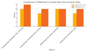
| Method | Steps | Ease of Use (1-5) | Popularity (1-5) |
| Using Browser Developer Tools (Chrome) | Open Developer Tools, Access Sensors, Set Geolocation, Reload the Page | 4 | 5 |
| Using Browser Developer Tools (Firefox) | Open Developer Tools, Enable Geo-Location Overriding, Set Coordinates | 3 | 4 |
| Mobile Device Emulation (Android) | Enable Developer Mode, Select Mock Location App, Use Apps like Fake GPS | 4 | 4 |
| Mobile Device Emulation (iOS) | Install Xcode, Open Project, Simulate Location, Choose Location | 3 | 4 |
Why Use Fake Geo-Location Data?
Testing mapping applications requires checking functionality across various locations. Moving to different places is impractical and time-consuming. Fake geo-location data allows developers to simulate multiple locations, ensuring the app works correctly everywhere.
Methods to Create Fake Geo-Location Data
Using Browser Developer Tools
Google Chrome

- Open Developer Tools: Right-click on the web page and select “Inspect” or press F12.
- Access Sensors: Go to More Tools > Sensors.
- Set Geolocation: Choose ‘Custom location’ and enter the desired latitude and longitude.
- Reload the Page: The page will now use the specified location data.
Firefox

- Open Developer Tools: Right-click on the web page and select “Inspect” or press F12.
- Enable Geo-Location Overriding: Go to Settings and check “Enable geo-location overriding”.
- Set Coordinates: Enter the latitude and longitude.
Mobile Device Emulation
Android
- Enable Developer Mode: Go to Settings > About Phone and tap “Build Number” seven times.
- Mock Location App: Select a mock location app from Developer Options.
- Use Apps like Fake GPS: Install an app like “Fake GPS” to set the desired location.
iOS

- Use Xcode: Install Xcode on macOS. Open the project and go to Debug > Simulate Location.
- Choose Location: Select a predefined location or create a custom one.
Tools for Generating and Validating Geo-Location Data
Geojson.io
A web service to generate GeoJSON data for points, paths, and polygons. It allows easy visualization and validation.
GeoJSONLint
This tool validates GeoJSON data by displaying it on a map, ensuring it matches the expected results.
Best Practices for Using Geo-Location Data
Handle Errors Gracefully
Always handle errors when accessing geo-location data. Users may decline permissions or disable location services. Use callback functions to manage these scenarios.
Watch User Location
Use the watchPosition method to track location changes. This is useful for applications that need continuous location updates.
Stop Watching Location
To conserve resources, stop watching the location when it’s no longer necessary using the clearWatch method.
Privacy and Compliance
Ensure compliance with data protection laws like GDPR. Provide clear terms of service and privacy policies to inform users about data usage.
Conclusion
Creating fake geo-location data is essential for testing mapping applications effectively. By using browser tools, mobile emulation, and cloud-based testing platforms, developers can simulate various locations without physically moving. This approach saves time and resources, ensuring the application works correctly across different geographies. For more detailed steps and tools, consider platforms like LambdaTest, Geojson.io, and GeoJSONLint.